Thursday, April 30, 2015

Z: Zion Canyon


Hey, it's the letter Z, and the last day of the A to Z Challenge! I have managed to post every day, and only had to fudge a little bit to make each post match its letter and/or my theme. I apologize right now for having done less well at visiting other bloggers, but I promise I'll keep right on working through the list. I'll never get to everyone, but I'll visit a lot before the next challenge rolls around.

And now, to our last Mountains and Valleys feature, one of the great ones, Zion Canyon, the heart of Zion National Park. I had the privilege of visiting Zion just this month (while my first week of posts were on auto-pilot!), not for the first time and I hope not for the last time.

Some basic info:
Zion Canyon was carved by the Virgin River. But the history of this desert canyon is water all the way back. The spectacular red cliffs are sandstone--laid down by an ancient sea. The canyon bottom is around 4000', with cliffs of 2000' or more leading up. And at the head of Zion Canyon, you enter the Virgin River Narrows, a slot canyon where you can see on any day the power of water--and a reminded to stay out of there when thunderstorms are in the region!

The park is located about 40 miles east of St. George, Utah, and was named by early Mormon pioneers. If it had been Norwegians, it would be Valhalla Canyon, because it's just that sort of place--it makes you figure it must be the home of the gods.

Without further ado, because a picture is worth a thousand words:
Overlooking Zion Canyon from the West Rim area (off Kolob Terrace Road).
Zion Canyon from the Observation Point trail.
Zion Trails are often not for the faint of heart. This is one of the more unnerving parts of the famous Angels Landing Trail.
One of the most beautiful things in the world is a cottonwood in leaf against the red canyons of the Colorado Plateau (the Utah canyon country). A ray of light hit just as we entered the Virgin River Narrows.
Hiking the Narrows. The water is very cold feeling in the morning, and deliciously cool by noon on a June day! You can see why you don't want to be here during a flash flood.

 ©Rebecca M. Douglass, 2015


Wednesday, April 29, 2015

Y: Yosemite


Y is for Yosemite, which is not only the 3rd or 4th US National Park created, it is also the name of one of the most spectacular valleys anywhere, the Yosemite Valley.

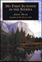
And when I think of Yosemite, both Valley and mountains, I think of John Muir, and My First Summer in the Sierra.
2116294  11074359  238727  1671548

I thought I'd share just a few of the many covers this one has, having been produced in about 50 editions since it was first published in 1911. Looking at them reminds me how long it's been since I last read the book, and that I need to dip back into it again. Based on the diaries Muir kept when he first entered the Yosemite Valley in 1869 as guide to a flock of sheep (the very things he himself called "hooved locusts), My First Summer records his reactions to the magnificent scenery he fell in love with an worked all his life to save. There is a bit of preaching in the book, and a bit of philosophy, some historical insights, and a touch of adventure. At times his prose waxes a bit too poetic for modern tastes, but it is always worth reading.

The Yosemite Valley--and the surrounding high country--is always worth visiting.

Yosemite Valley from the Yosemite Falls trail.
 There is a good reason I didn't include a photo of the falls from that hike: it was October, and there was no water going over the falls. None.
Half Dome from the Valley floor. Boys doing what small boys do in gorgeous places.
Vernal Falls. Note the water spots on lens--they don't call it the Mist Trail for nothing! This was in June, when run-off was at its peak. A week later, 3 hikers were swept over the falls after ignoring signs about not wading or swimming in the river above the falls. Believe those signs!
Nevada Fall and Liberty Cap.
Yosemite high country--looking back toward the Valley from the Tioga Pass road.

©Rebecca M. Douglass, 2015


Tuesday, April 28, 2015

Xavier Xanthum: X Marks the Spot


I checked our huge world atlas, and found no mountains starting with X. There are rivers in China, of course, but I don't know anything about them, so instead of doing research, I returned to my favorite space explorer, expressly invented for my first A to Z Challenge...Xavier Xanthum, Space Explorer! Here, at half-flash size (just over 500 words) is a bonus fiction feature. I couldn't find any photos...

 Xavier Xanthun: X Marks the Spot

The Wanderlust gave a terrific lurch as it entered the atmosphere, and Xavier Xanthum, Space Explorer, felt his body stretch the crash straps as they decelerated at far more than the usual rate. He didn’t even have time to ask the computer what was up before another bump indicated that they were on the ground.

Xavier sat back and ran a hand under the straps to ease the tightness. “Larry? What was that all about?”

“My apologies, Xavier.” The computer’s voice sounded mechanical, which meant he was busy with other tasks. “The ground occurred a great deal sooner than anticipated.”

Xavier sat and worked that out. “The atmosphere was thinner than you expected?”

“Not precisely. There appeared to be an extrusion from the planet’s surface at this point. It was not on any charts.”

“We have charts for this planet?”

The computer fell silent for a minute, then the floating eyeballs that were Larry’s preferred manifestation appeared next to Xavier, who had started to unbuckle his safety straps. “You might not want to do that just yet. I am attempting to access charts. There appears to be some kind of local communications system.”

Xavier felt a stir of interest and concern. Inhabited planets were exciting. Often, too exciting. You never knew what might bite you.  An inhabited planet that wasn’t indicated as such on any charts was particularly worrisome. “What are you getting?”

Larry hesitated before answering. As a computer, he did not need to pause to marshal his thoughts, but Xavier had noticed that Larry liked to do so anyway. “The local sub-ether information system has provided a map.”

“Great! So what does it tell us?”

A moment later a map grid appeared on Xavier’s viewscreen. It showed a few concentric contour lines with an X in the center, the lines getting very close together indeed near the edges, indicating steep slopes in all directions. A little flag read, “You are here.”

“Zoom out, Larry. We need some context.”

Again, that odd pause before Larry answered, his tone completely flat and mechanical. “It will not zoom out. Attempting again.”

Xavier watched in fascination as the image fluttered a bit, and the flag was replaced with another text, rendered as “X marks the spot.”

“What spot would that be, Larry?”

“I believe it is the spot where we are.”

“How very helpful, Larry.” Sarcasm was wasted on the computer, but it made Xavier feel better.

“Would you like to attempt to explore further?”

Xavier gave it some thought. The planet was inhabited. The inhabitants had communications systems, which they used, apparently, to communicate as little as possible. His mind drifted off to the last planet they had visited, where settlers had built a lovely little resort by a warm ocean. “Let’s just go back and mark our X on that beach again,” he said, a little dreamily. He settled back in his chair, and the eyeballs lingered on him as his eyes closed, a smile playing about his face.

After take-off, Larry made some adjustments to the interplanetary chart. Hereafter, travelers would know that this world featured a very high mountain that went by the name of X. And some rather unhelpful inhabitants.
###

©Rebecca M. Douglass, 2015